
NHC Tracking ‘Future Jerry’ In The Atlantic
Tropical Storm Jerry could form soon in the Atlantic Basin and while it could eventually brush the Leeward Islands, current indications are it could once again curl north into the open Atlantic this weekend. A second area in the far southwest Gulf is also being watched for slim development chances.
(MORE: How Hurricane Season Usually Changes In October)
Where The East Atlantic System Is Now
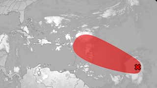
A cluster of showers and low pressure known as a tropical wave is between Africa and the Lesser Antilles marked as a red “X” in the map below.
The National Hurricane Center is calling this tropical wave “Invest 95L,” a term used to identify features of interest that could develop, allowing special high-resolution computer forecast models to zero in on that.
The showers and low pressure above the surface are becoming better organized. The first Hurricane Hunter mission into this system is scheduled for Wednesday morning, if needed that soon.


Possible NHC Development
(The possible area(s) of tropical development according to the latest National Hurricane Center outlook are shown by polygons, color-coded by the chance of development over the next seven days. An “X” indicates the location of a current disturbance.
)
95L’s Future
This disturbance will continue to move quickly toward the west-northwest the next few days.
That may bring it near or just north of the Leeward Islands by Thursday night or Friday.
Most computer forecast model guidance suggests this could become Tropical Storm Jerry — the 10th storm of the 2025 Atlantic hurricane season — by that time, if not sooner.
While it’s too soon to determine its future beyond that, it’s most likely this system will then curl north into the central Atlantic, as many other storms this season have. Therefore, this is not a threat to the mainland U.S.
When it makes that northward curl will be important, meaning the difference between heavier showers and winds for the Leeward Islands, Puerto Rico and the Virgin Islands or just a brush of showers, gusty winds and high surf.


Model Forecast Tracks
(The lines on this graphic represent several of the many track forecasts from various computer models. This is not an official forecast, but these are used as guidance for creating the projected path.
)
Southwest Gulf
The NHC is also monitoring another area over Mexico’s Yucatán Peninsula for development. It’s marked by the “X” and color-coded blob in the first map near the top of this article.
For now, there is a less than 50/50 chance it could develop in the Bay of Campeche in the far southwest Gulf before it moves into eastern Mexico by Thursday.
The main threat, regardless, is locally heavy, flooding rainfall across Belize, northern Guatemala and southern Mexico the next few days.
Check back with us at weather.com for the latest on these, and other happenings in the 2025 Atlantic hurricane season.
Jonathan Erdman is a senior meteorologist at weather.com and has been covering national and international weather since 1996. Extreme and bizarre weather are his favorite topics. Reach out to him on Bluesky, X (formerly Twitter) and Facebook.


