


_July%202024.jpg&c=0&w=700)


- Beryl’s strike on Jamaica has begun.
- It will then strike the Cayman Islands, followed by Mexico’s Yucatan Peninsula.
- It’s also a threat to the western Gulf Coast, from Texas to Mexico early next week.
- Hurricane Beryl became the earliest Atlantic Category 5 overnight after hammering the Windard Islands Monday.
Hurricane Beryl has begun a potentially devastating strike on Jamaica and will then hammer the Cayman Islands and the Yucatan Peninsula before its final chapter in the Gulf of Mexico that will likely include impacts in eastern Mexico and Texas.
Current status: Beryl has begun its lashing of Jamaica as its eyewall containing its strongest winds continues to draw closer. On Beryl’s eastern flank, bands of rain continue to wrap into parts of Haiti, which could result in flooding and mudslides.
(MORE: Beryl Was Earliest Category 5 On Record)

Beryl’s Current Wind Field Size
(The orange circle shows the extent of the system’s tropical-storm-force winds (at least 39 mph). The purple circle indicates the extent of hurricane-force winds (at least 74 mph), according to the National Hurricane Center. Current sustained winds at reporting stations are also plotted. )
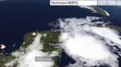
Here’s where warnings and watches are in effect: Hurricane warnings continue in Jamaica and the Cayman Islands.
Hurricane warnings are also in effect for parts of Mexico’s Yucatan Peninsula, including Costa Maya, Tulum, Cozumel and Cancún.
Tropical storm warnings surround the hurricane warnings in Mexico’s Yucatan Peninsula north of Cancún and south of Costa Maya. A tropical storm watch is in effect in much of the rest of the Yucatan Peninsula as well as in northern Belize as far south as Belize City.
Those in Jamaica should remain in safe shelter until the hurricane passes. Areas under hurricane warnings from the Cayman Islands to Mexico’s Yucatan Peninsula should rush preparations to completion.

Here’s what to expect next from Beryl across the Caribbean: Beryl will take a west-northwest track in the Caribbean Sea through the rest of this week. Although the hurricane will eventually lose some intensity because of increasingly hostile wind shear, it will still pose a considerable danger. Here’s the general timeline
- Through Wednesday evening: Beryl will continue to lash Jamaica with potentially devastating winds, especially over mountainous terrain, and life-threatening storm surge flooding that could reach 6 to 9 feet above normal tide levels where winds blow onshore on the coast into the evening. Torrential rainfall could last through the overnight hours, triggering flash flooding and landslides in Jamaica. This will likely be the strongest hurricane to strike Jamaica in almost 17 yearssince Hurricane Dean in 2007.
- Wednesday night and early Thursday: Beryl will make its closest approach to the Cayman Islands, particularly Grand Cayman, with storm surge flooding, high winds and heavy rain. This could be Grand Cayman’s strongest hurricane strike since November 2008’s Hurricane Paloma.
- Thursday night and Friday: While conditions will deteriorate Thursday night, Beryl is expected to make a landfall as a hurricane in Mexico’s Yucatan Peninsula early Friday morning, anywhere from the Belize border and Costa Maya to Cozumel. Storm surge flooding, potentially damaging winds and flooding rain are all possible. Heavy rain and strong wind gusts will continue in the Yucatan Peninsula through Friday.
(MORE: What The Forecast Cone Means, And Doesn’t)

Current Information And Projected Path
(The red-shaded area denotes the potential path of the center of the tropical cyclone. It’s important to note that impacts (particularly heavy rain, high surf, coastal flooding, winds) with any tropical cyclone usually spread beyond its forecast path.)
U.S. concern: Beryl is likely to emerge in the southwest Gulf of Mexico Friday night or early Saturday after being steered by a heat dome of high pressure over the Southeast U.S.
There is typically large uncertainty in Beryl’s future once it’s in the Gulf of Mexico.
That Southeast U.S. upper-level heat dome is expected to both weaken and retreat off the Southeast coast, leaving a gap between that and a western U.S. heat dome.

Because of that, some computer forecast models suggest Beryl could eventually take a bit of a northwest curl in the western Gulf of Mexico and slow down a bit. That opens the door to a track anywhere from eastern Mexico’s Gulf Coast to Texas sometime Sunday or early Monday.
Beryl should have lost strength by the time it reaches the southwest Gulf because of wind shear and land interaction, however it could still bring significant impacts to the Gulf Coast as either a tropical storm or hurricane. Some restrengthening is expected before its final landfall.
For now, residents along the Gulf Coast from eastern Mexico to Texas should monitor forecast updates closely and have their hurricane plans ready to go.

Coastal threats could begin this weekend: Well ahead of Beryl, onshore winds could lead to increasing surf, rip currents and coastal flooding along parts of the Gulf Coast from eastern Mexico to Texas and western Louisiana beginning as soon as Saturday, continuing until just after Beryl’s final landfall. The rip current threat could even extend farther east along the northern Gulf Coast, as well.
Keep this in mind if you have holiday weekend beach plans along these stretches of the coastline.
Just a couple of weeks ago, Tropical Storm Alberto triggered significant coastal flooding along the Texas coast.
Recap Of Beryl’s Historic Windward Islands Landfall
Beryl made landfall just after 11 a.m. EDT Monday over the Grenadan island of Carriacou with maximum sustained winds of 150 mph. Among only two other Category 4 hurricanes in history near Grenada and St. Vincent and the Grenadines, Beryl was the strongest by wind speed.
(MORE: All The Ways Beryl Has Already Made History)
Storm reports: Storm chasers Brandon Clement and Jonathan Petramala reported the roof ripped off of a building they were reporting from on Carriacou Island late Monday morning as the eyewall moved in. The National Hurricane Center’s 11 a.m. EDT Monday advisory cited “multiple reports of downed trees, flooded streets, power outages and storm surge flooding in the Grenadines, Grenada, Barbados and Tobago.”
After briefly weakening to a Category 3 overnight following an eyewall replacement cycle, the hurricane once again returned to Category 4 strength Monday morning.
Its wind field grew larger since Sunday, with hurricane-force winds now extending out up to 40 miles from Beryl’s center.
While its eyewall passed south of Barbados, a 69 mph gust was clocked early Monday at Grantley Adams International Airport, the island’s major airport. Grenada clocked a wind gust up to 121 mph as the center of Beryl tracked just north of the island. A gust to 64 mph was reported on St. Lucia, as well.
Beryl strengthened after that strike on Carriacou Island.
MORE ON WEATHER.COM
- Why Hurricane Season’s More Active Phase May Arrive Earlier
- How To Prepare For Hurricane Season
- What’s Been Deadliest In US Hurricanes, Tropical Storms Lately May Surprise You
