Hurricane Milton remains strong as it heads toward Florida
FOX 13 meteorologist Jim Weber is tracking Hurricane Milton. The storm is currently a Category 4 storm.
TAMPA, Fla. – Hurricane Milton strengthened back into a Category 5 storm Tuesday evening with maximum sustained winds topping 165 miles per hour.
As of 5 p.m. on Tuesday, Milton was located at 23.0N and 86.9W, which is about 280 miles southwest of Tampa.
According to the National Hurricane Center, Milton wobbled earlier on Tuesday, but it is moving east-northeast at nine miles an hour.
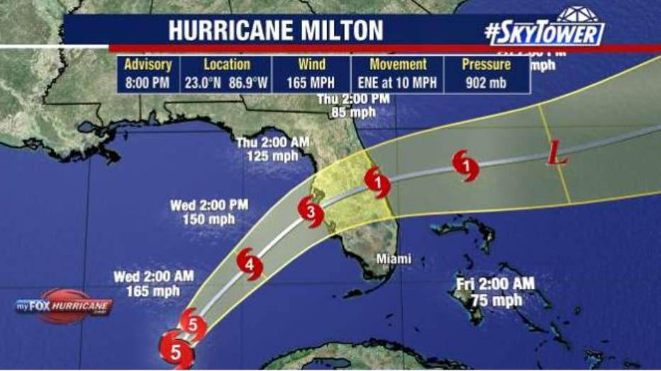
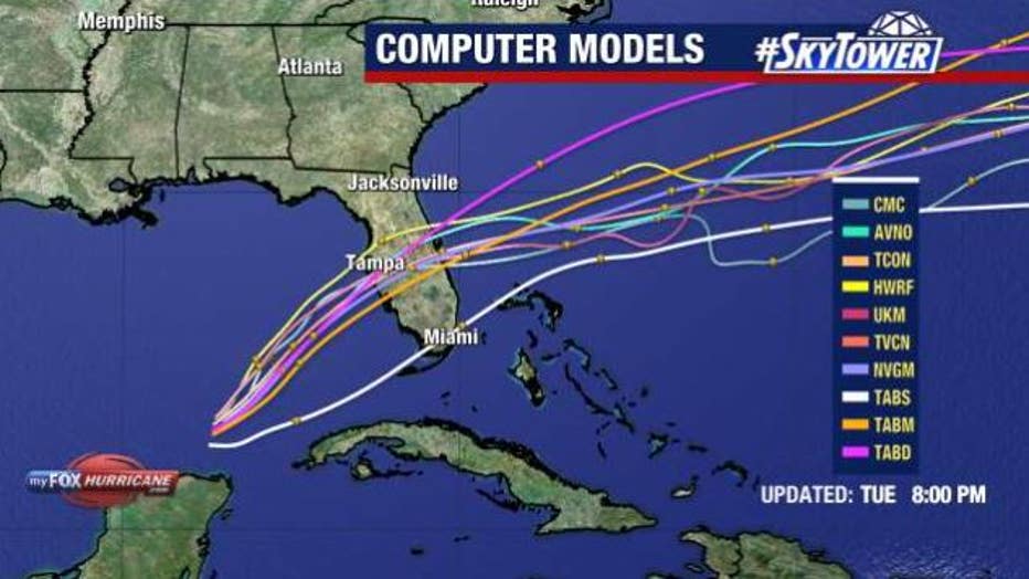
Hurricane Milton is expected to increase speed and turn toward the northeast Tuesday night through early Thursday.
The center of Milton will move across the eastern Gulf of Mexico through Wednesday, make landfall along the west-central coast of Florida Wednesday night, and move off the east coast of Florida over the Atlantic Ocean on Thursday.
READ: Life-saving satellite tech likely in your pocket to use for emergency calling when disaster strikes
Hurricane-force winds stretch 30 miles out from the center of Hurricane Milton and tropical-storm-force winds extend outward up to 140 miles.
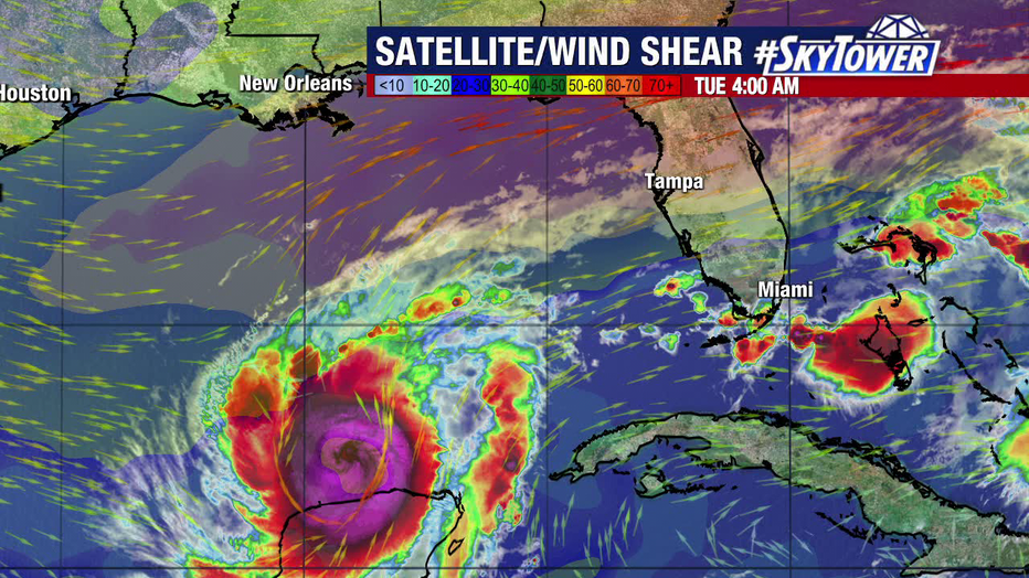
Hurricane Milton is expected to encounter wind shear prior to landfall, which will likely lead to some weakening. Regardless, it will be a major hurricane upon landfall.
On Wednesday, Milton is expected to encounter a less favorable environment with strong shear, which meteorologists believe will lessen the intensity of the storm.
Even if the storm weakens, it is expected to be a major hurricane upon landfall on Florida’s Gulf coast.
Governor Ron DeSantis declared a state of emergency for 51 Florida counties, while President Joe Biden has approved a federal disaster declaration ahead of Milton.
Watches and Warnings
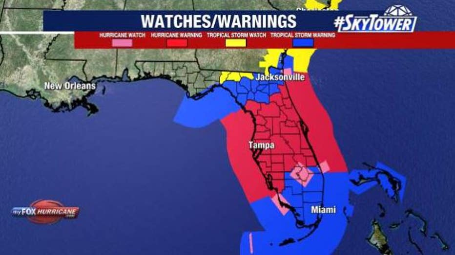
A storm surge warning is in effect for Florida’s west coast from Flamingo northward to Suwannee River, including Charlotte Harbor and Tampa Bay, as well as the Sebastian Inlet Florida to Altamaha Sound Georgia, including the St. Johns River.
A hurricane warning is in effect for Florida’s west coast from Bonita Beach northward to Suwannee River, including Tampa Bay and on Florida’s east coast from the St. Lucie/Martin County Line northward to Ponte Vedra Beach.
READ: Hurricane Milton evacuees injured in plane crash near St. Pete Pier: Police
Hurricane conditions are expected in the hurricane warning area across Florida beginning late Wednesday through early Thursday.
Storm Surge
The National Hurricane Center says the combination of a dangerous storm surge and the tide will cause normally dry areas near the coast to be flooded by rising waters moving inland from the shoreline. The water could reach the following heights above ground somewhere in the indicated areas if the peak surge occurs at the time of high tide:
- Anclote River, FL to Englewood, FL – 10-15 ft
- Tampa Bay – 10-15 ft
- Englewood, FL to Bonita Beach, FL – 8-12 ft
- Charlotte Harbor – 8-12 ft
- Chassahowitzka, FL to Anclote River, FL – 5-10 ft
- Bonita Beach, FL to Chokoloskee, FL – 5-8 ft
- Chokoloskee, FL to Flamingo, FL – 3-5 ft
- Yankeetown, FL to Chassahowitzka, FL – 3-5 ft
- Sebastian Inlet, FL to Altamaha Sound, GA – 3-5 ft
- Altamaha Sound, GA to Edisto Beach, SC – 2-4 ft
- Suwannee River, FL to Yankeetown, FL – 2-4 ft
- Dry Tortugas – 2-4 ft
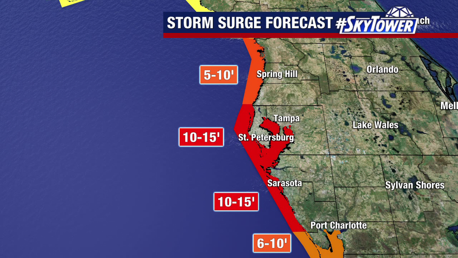
Storm surge from Hurricane Milton could reach 10-15 feet in the worst areas.
FOX 13 meteorologists say where Hurricane Milton makes landfall will make a huge difference in the amount of storm surge.

Landfall location is key when it comes to major impacts from Hurricane Milton, including life-threatening storm surge.
What is the difference between a watch and a warning?
A hurricane warning means that hurricane conditions are expected somewhere within the warning area. A warning is typically issued 36 hours before the anticipated first occurrence of tropical-storm-force winds, conditions that make outside preparations difficult or dangerous.
A hurricane watch means that hurricane conditions are possible within the watch area. A watch is typically issued 48 hours before the anticipated first occurrence of tropical-storm-force winds, conditions that make outside preparations difficult or dangerous.
Hurricane Milton: Mandatory evacuations begin in Tampa Bay Area
A storm surge Warning means there is a danger of life-threatening inundation, from rising water moving inland from the coastline, during the next 36 hours in the indicated locations.
A storm surge Watch means there is a possibility of life-threatening inundation, from rising water moving inland from the coastline, in the indicated locations during the next 48 hours.
How much rain will we get?
Florida can expect to see 6 – 12 inches of rain with some places getting up to 18 inches.
This rainfall brings the risk of catastrophic and life-threatening flash and urban flooding, along with moderate to major river flooding.
STAY CONNECTED WITH FOX 13 TAMPA BAY:


