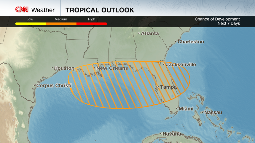
There’s growing concern for another significant rain and flooding event this week, this time along the Gulf Coast, from what could become the Atlantic basin’s next tropical system.
The potential storm’s flood threat is just the latest in what has been a summer full of deadly and devastating floods.
Right now, the would-be storm is a broad area of showers and thunderstorms over the Florida Peninsula. It will drift west into the Gulf by midweek where it has a medium chance of becoming a tropical depression, according to the National Hurricane Center.

If it can muster a more defined center of circulation and strengthen further it would become Dexter, the fourth named storm of the Atlantic hurricane season — a mark typically reached around mid-August.
If it does form, it would do so just off the Gulf Coast — a reminder that storms are more likely to form in the warm, shallow water closer to land in July. Warm water acts like fuel for storms to form and strengthen and ocean surface temperatures are well above average where the system is expected to track.
Conditions aren’t looking favorable for a strong storm right now because this system will likely not have much time to mature over water and will also have to overcome hostile upper-level winds that can rip apart storms.
But a few reputable forecast models are predicting a more organized system, potentially a tropical storm, in the Gulf by late week. The outcome could hinge on the system’s track. If it dips further south and spends more time over the Gulf it could become stronger if it can withstand the upper-level winds on its journey.
Even if it isn’t named, this system will bring tropical downpours to Florida and parts of the Gulf Coast over the next several days. This surge of moist tropical air helped drench Daytona Beach with 2.25 inches of rain on Tuesday, breaking its previous daily record of 2 inches set on July 15, 1935.
There’s a Level 2 of 4 risk of flooding rain in parts of the Florida Peninsula including Tampa and Orlando Wednesday morning as the system taps into rich tropical moisture and enhances rainfall rates and the flood potential. The most intense storms are likely in the afternoon and evening as the system drifts across the state. Rainfall totals could range between 1 to 3 inches.
But the most serious flood threat will come later this week and into the weekend as the system drifts west into parts of the north-central Gulf Coast, including Alabama, Mississippi and southeast Louisiana. Heavy rain could be long-lasting once it begins, possibly as soon as Wednesday night.
Flash flooding is the main concern, especially if rain bands repeatedly track over the same areas which could happen if the system moves slowly and lingers.
A Level 2 of 4 threat for flooding rain is in place Thursday for southeastern Louisiana, including New Orleans and parts of coastal Alabama and Mississippi. By Friday, the threat increases to a Level 3 of 4 for parts of Louisiana including Baton Rouge over fears that heavy rain could linger. Several inches of rain are possible in the worst-case scenarios.
It’s clear that heavy rain and flooding will threaten much of the north-central Gulf Coast, but exactly where and how much remain in question. It will all depend on how strong the system becomes, where it tracks and how fast it moves – questions that will become sorted in the next couple of days.
This story has been updated with additional information.


.jpg?w=700&c=0)


