Here comes fall and it is packing a punch. Tomato plants in the Pittsburgh area will need to be brought inside with frost possible tonight.
Any Alert Days Ahead? None.
Aware: Frost Advisories have been posted for many communities for tonight. More will be posted on Friday morning
Highs today were hit at midnight last night, coming in at 65°. And temperatures will be kind of all over the place today. We will see morning lows dipping to the mid to low 50s this morning.
KDKA Weather Center 
We will then see afternoon temperatures hitting the low 60s with sunny skies. Those clear skies will allow temperatures to really plunge in the overnight hours with the dry and cool air mass that is now in place. Our daily low will be hit just before midnight tonight; I have Pittsburgh at 45° at that time.
We will see temperatures plunge all the way down to around 40° for our Thursday morning temps. A number of places will see temperatures fall to the mid 30s, easily cool enough for widespread frost. This is the last call to bring in your tomatoes before frost impacts them.
I was a bit surprised that even with the cool down that is heading our way, our skies will clear out quickly today, before sunrise, and stay that way through Saturday. This means not just one but three days in a row we will see morning lows dipping to temperatures cool enough for widespread frost. The coolest morning of the week will be on Friday, with Pittsburgh dipping down to around 37 for the morning low. I believe we will have multiple communities dipping to 32 degrees or cooler. Brrrr. While not as cold, Saturday morning temperatures will also be cool enough with conditions primed for more frost.
I really think we will see our next rain on Sunday. Will it rain for the Steelers game? I can’t rule it out, but the best answer to those wondering is a simple I need more data to make a confident prognosis. Currently, model data is consistent with the development of an area of low pressure developing off the East Coast. This system will bring plenty of rain for places like Harrisburg, Philadelphia, and Baltimore. Even State College should see some scattered showers from this system on Sunday into Monday.
For places west of the Laurel Highlands, things aren’t so clear cut, with just an isolated to scattered rain chance for the afternoon and overnight hours on Sunday. Both the EURO and GFS long-range models have some showers around during the Steelers game, with the EURO being more aggressive with our rain chance.
KDKA Weather Center 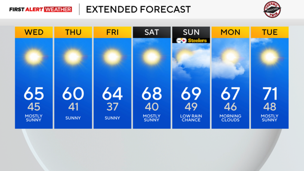
At this point, I will keep our Sunday and Monday rain chances in the isolated range, meaning the areal coverage area will be at 30 percent or less.
WEATHER LINKS:
Current Conditions | School Closings & Delays | Submit Your Weather Photos