plays in preseason finale")

BRYAN, Texas (KBTX) – After over a month of no measurable rainfall at Easterwood Airport, the Brazos Valley is in desperate need of a weather pattern switch-up. While not the strongest, our next weather system could at least bring a sip of water to lawns across the area and a taste of fall behind it.
Saturday morning update – Model data has come into better agreement for scattered thunderstorms moving into the Brazos Valley this evening as the long awaited cold front arrives.
A broken line of showers and storms is expected to form just north or over the Brazos Valley as the front moves southeastward through the area this evening. While the severe threat is higher to our northeast, we can’t rule out some isolated wind gusts above 50mph, especially across our northern counties.
Timing – Timing is relatively unchanged from where we’ve been thinking the past couple days, with storms arriving/developing over our northern counties as early as 6pm, and leaving our southern counties as late as 11pm.
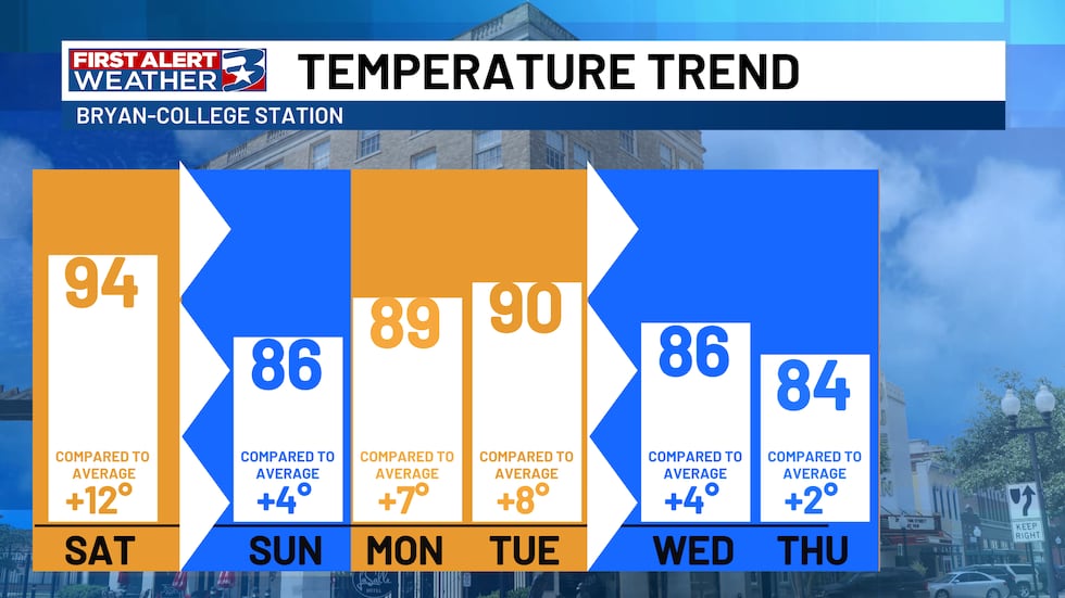
While most missed out on the rain Friday, Saturday brings us the best chance we have seen in over 40 days. A cold front will spend the day traveling across Texas, before arriving in the Brazos Valley around dinnertime. The bullseye for rain and storm activity is across the Ark-La-Tex region, where the Storm Prediction Center has a slight (2 out of 5) risk in place. The agency has also extended the marginal (1 out of 5) risk to include more of the Brazos Valley, mainly along and east of I-45.

If we find strong to severe storm activity, it will likely be out ahead of the front. This is where we have more available storm fuel and could pop up an isolated storm or two. When it comes to impacts, our main focus will be gusty winds. But an isolated storm with pea to pocket change-sized hail cannot be ruled out. As for heavy rain and flooding, while some ponding is possible under a heavier shower, these storms look scattered and quick enough to not lead to a flooding concern.
After the front passes through, drier air will filter in behind, setting up a much more fall-like feel. Don’t get used to it. Onshore flow will quickly reestablish itself by Monday afternoon, making things feel more spring-like until our next system rolls in around midweek.
Bottom line – some areas could find their first measurable rainfall in over a month, and there is a chance that a storm or two could pack a punch. While that chance is low, it is not zero. As the forecast evolves, we will keep you updated. Stay tuned!
Copyright 2025 KBTX. All rights reserved.